
a3dscansurvey@gmail.com - Topographical Surveys -
Measured Building Surveys -
a3dscansurvey@gmail.com - Topographical Surveys - Measured Building Surveys -
Our Services
-
Using laser scanning technology, we quickly gather millions (and often billions) of data points. This creates a precise 3D pointcloud of the as built environment. We can then produce Topographical and Measured Building Survey deliverables to Architects or direct to clients seeking to understand there own homes on a more granular level of detail.
-
From the collected point cloud data we can provide accurate 3D sketch up models to varying levels of detail (determined by the client). These 3D models can be simple massing and volume models of structures on the site, simple terrain models showing the contours and undulations, or fully detailed internal and external models which can then be manipulated for your proposed works.
-
Laser scanning is becoming an industry standard for Measured Building Surveys, giving rapid and thorough data collection of as-built environments.
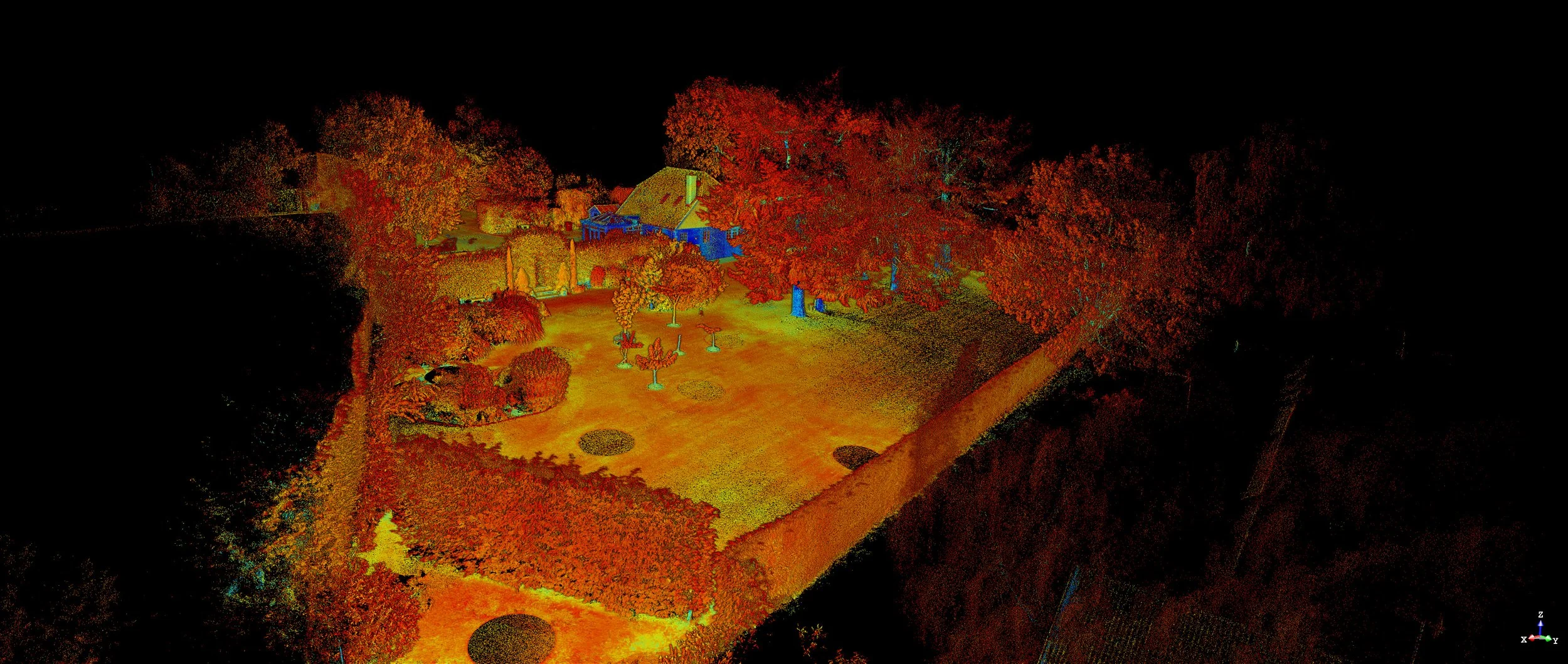
Laser scanning is an advanced technology that has revolutionised the way data is captured in the built environment. Utilising a high-precision laser scanner, we can collect millions of data points in a fraction of the time it would take to undertake the same survey with a traditional total station. Laser scanning is an all encompassing survey and captures as much data as it can physically see. The point cloud data can be referenced at anytime after the survey to check areas not originally within the scope of works. This method of surveying therefore effectively eliminates rework and the need to go back to the property at a later date.
3D laser scanning creates a detailed 3D model of the surveyed area, capturing not only the dimensions and geometry of the structure but also its spatial relationships. The accuracy and efficiency of laser scanning make it particularly advantageous for residential building surveys, allowing for comprehensive documentation and analysis that supports effective planning, design, and renovation projects.
With the resulting point cloud data, we can deliver precise measurements and insights, enhancing decision-making and minimising risks throughout the development process.
-
We undertake the survey on a mutually agreed time and date.
On most dwellings this can be between 1-4 days depending on size and complexity, however we will provide anticipated survey timings upon quotation.
We carry out all surveys with a survey grade Trimble X7 3D Laser Scanner which captures data at 500,000 points per second!
-
Processing the survey data from the point cloud takes time to ensure accuracy and supply of the relevant data the client needs.
Firstly the point cloud is checked and ensured it is registered correctly, we then begin the data extraction and linework which forms the 2D plans we supply.

-
The deliverables in nearly all projects will be standard 2D CAD drawings in PDF format and DWG files for you to take forward with your architect or contractor.
The 3D point cloud file can also be made available for 3D modelling purposes (or we can provide this service).